MemoryC
Customer Reviews

Hello!

Delivery options from only £2.99
30-day Money Back Guarantee
Easy and Hassle-Free Returns
Online Since 2003

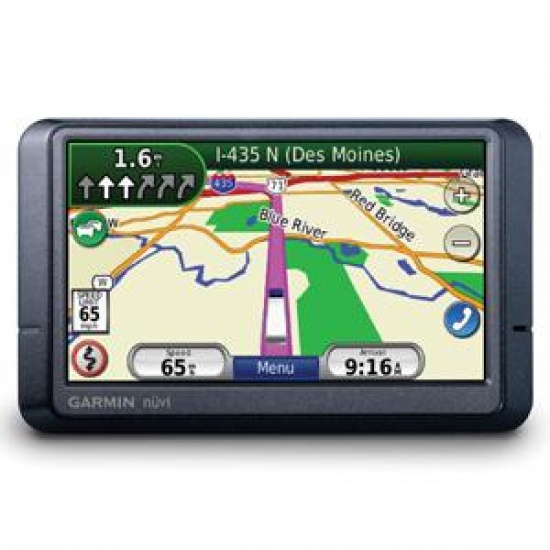
Garmin Nuvi 465T 4.3" Widescreen Truck GPS Navigator Europe maps, Bluetooth by Garmin


Garmin Nuvi 465T 4.3

No longer available. See alternative options

Key Features

  • Garmin Nuvi 465T
  • 4.3" Truck GPS system
  • Full European mapping
  • UK Truck data preloaded
  • Bluetooth
  • FM Traffic receiver
  • LaneAssist
See full specifications
See product description

Details
Garmin Nuvi 4.3" Widescreen designed for use in trucks. Includes full maps of Europe and UK truck data. Bluetooth and lifetime FM traffic receiver also included. Lane Assist feature and touchscreen display.

The Nuvi 465T is Garmins latest GPS system designed for use in trucks. It can even be integrated with existing fleet management systems (read more about this on the Garmin website).

Some of the main features of the Garmin Nuvi 465T include (but are not limited to):

- Widescreen 4.3" touchscreen display
- Full European mapping (latest City Navigator version)
- UK truck data
- Lane Assist
- Bluetooth hands-free calling
- FM Traffic receiver, with lifetime subscription
- Multi-point planning
- Safety alerts making the driver aware of potential hazards ahead

Further details from Garmin:


No more narrow country lanes or impossible maneuvers with the nüvi 465T – our first nüvi designed specifically for the trucking professionals. Featuring a preloaded UK truck attribute database*, specialised routing options and truck friendly points of interest, this full-featured navigator was made for life on the road. The nüvi 465T can save multiple vehicle profiles which can tailored to what you’re driving and what you’re hauling.

Know The Way
With detailed maps providing turn-by-turn directions that call out streets by name, the nüvi 465T provides specialised routing to support truck-related restrictions (customisable by height, weight, length, width and hazardous materials). Simply enter dimensions and load restrictions and nüvi 465T guides you according to your requirements. You can even enter multiple-point routing so that you can take a more efficient route between multiple stops along your trip.

Steer Clear of Hazards
Know what lies in your path with the nüvi 465T. It displays warning information of upcoming road conditions to make drivers aware of possible hazards along the route such as sharp curves and steep grades. You’ll also get lateral wind warnings and notification when the road narrows. It’s the safe way to travel down the Motorway.

Get The Big Picture
Featuring a 4.3” high-resolution touchscreen display, the nüvi 465T provides users with a wealth of information in great detail. Preloaded with detailed, street-level maps of Europe, the nüvi 465T speaks street names so drivers will receive turn-by-turn, voice-prompted directions, such as “turn right on Bridge Street.” The nüvi 465T also comes standard with lane assist, which safely guides drivers to the right lane at the right time – especially helpful when navigating complex motorway interchanges.

Avoid Traffic Tie-ups
Put traffic jams behind you with nüvi 465Ts integrated FM traffic receiver. Receive free alerts about traffic delays and road construction that lie ahead on your route. Simply touch nüvi's screen to view traffic details or detour around the problem area.

Integrate with your existing fleet management system
Whether your business acts globally or locally, the nüvi 465T can be integrated into your existing or planned fleet management system by one of Garmin's growing list of authorised fleet management partners. Garmin GPS solutions are a key part of today's most useful, versatile, and cost-efficient fleet monitoring solutions. With Garmin GPS, drivers and dispatchers work together to improve customer response, optimise fleet resources, and ultimately, achieve lower costs and higher profits for the company.


*Additional free truck attribute data will provided until the end of 2010.
Specifications
RECOMMENDED USE Truck GPS systems
DISPLAY SIZE 4.3" Widescreen
PRELOADED MAPS European maps, latest version
DISPLAY TYPE WQVGA color TFT with white backlight
9.7 x 5.7 cm
BLUETOOTH SUPPORT Yes
VOICE PROMPTS Yes, spoken
3D MAP VIEW Yes, 2D also available
TOUCHSCREEN Yes
BUILT-IN STORAGE Internal solid state
PC CONNECTION USB
SLOTS SD card slot (card not included)
ACCESSORIES INCLUDED FM traffic receiver with 12/24 volt power cable
Dash mount
USB cable
Dashboard disc
Quick start manual
BATTERY Built-in rechargeable lithium-ion
Battery life up to 4 hours
MP3 PLAYER No
MOVIE PLAYER No
AERIAL Built-in aerial
DIMENSIONS 12.2 x 7.4 x 2.0 cm
WEIGHT 173g
WATERPROOF No
User Reviews
No reviews yet
Add your review
 
Cookies help us deliver the best experience on our website. By using our website, you agree to our use of cookies. Learn more
Loading...